Thinking about buying or selling a river-access or view lot near Jasper but not sure how to price it? You are not alone. In the Buffalo River corridor, value depends on more than acreage and road frontage. You also need to weigh access rights, flood risk, buildability, and how rare the setting really is. This guide breaks down what drives premiums, how to evaluate a specific parcel, and a simple framework you can use to set a confident price. Let’s dive in.
What drives value near Jasper
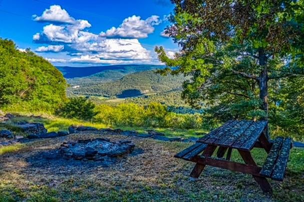
Near Jasper, the Buffalo National River and surrounding public lands create powerful demand for private lots with access or views. At the same time, steep bluffs, karst geology, and limited utilities make some parcels costly or difficult to build on. That mix of high demand and constrained supply is why two similar-looking lots can be priced very differently.
Buyers in this area often include paddlers and anglers, second‑home owners seeking a retreat, and local owners who want a scenic lifestyle. Each buyer group values different features. A kayaker may care most about reliable river access, while a second‑home buyer may pay a premium for a protected bluff view and privacy.
Legal access types to the river
Before you price a “river” lot, confirm what kind of access it actually has. The Buffalo River is a National River with extensive public lands, so private control and use can be limited even for adjacent owners.
- Deeded waterfront: The boundary reaches the shoreline. This usually commands the highest premium if the building site is practical and above flood elevations.
- Recorded access easement: A documented right of passage to the river. Terms vary. Some easements allow only foot access or shared paths, which reduces value compared to deeded waterfront.
- Informal or prescriptive paths: Unrecorded historical use is risky. Do not assume marketable access without recorded rights.
Also consider road access. A paved county road with a maintained approach adds marketability compared to a steep private track. If access crosses another parcel, verify the easement width, location, and maintenance obligations.
Flood, slope, soils, and buildability
Your premium rises or falls with buildability. A spectacular view means less if you cannot build the home you want.
- Flood zones: Check FEMA Flood Insurance Rate Maps to see if the building area lies in a Special Flood Hazard Area. Flood zone status can affect mortgage options, insurance costs, and acceptable foundation designs.
- Slope and topography: Bluffs, ledges, and steep grades reduce usable area and increase site costs for grading, driveways, and foundations.
- Karst and soils: Thin soils over limestone and potential sink features are common. Many sites need a certified evaluation and sometimes engineered septic systems under Arkansas Department of Health rules.
- Setbacks and sensitive areas: Wetlands, jurisdictional waters, and riparian setbacks can limit where you build. Where parcels adjoin National Park lands, additional restrictions or reviews may apply.
- Utilities: Public water, sewer, gas, and electric are not guaranteed. Off‑grid systems or long utility runs can be significant cost factors.
If the buildable area is small, within flood hazard, or requires expensive wastewater or driveway solutions, the river premium can shrink quickly.
Scarcity and demand in Jasper
Public ownership along the Buffalo River reduces the amount of private riverfront. Conservation easements and rugged topography further limit the supply of truly buildable waterfront and protected-view parcels. That scarcity can boost prices, but only when the parcel is usable. Overpricing happens when sellers count the view but ignore flood, septic, or access hurdles that buyers must solve.
Market signs to watch include days on market for riverfront and bluff-view lots, the gap between list and sale prices, and listings that stall because of buildability or access issues. In this submarket, the best‑priced parcels pair scenic appeal with practical development paths.
A practical pricing framework
Below is a simple step‑by‑step approach you can use to evaluate a specific parcel. It is not a formal appraisal, but it will keep your pricing grounded and defensible.
Step A: Set a baseline value
Start with the market value for comparable non‑water lots of similar size and location around Jasper. That becomes your baseline. You will adjust up or down based on access, buildability, flood risk, and encumbrances.
Step B: Document value drivers
Gather proof for each attribute. Use deeds, plats, surveys, FEMA maps, soils reports, and recorded easements to confirm the facts.
- Access to water: Deeded waterfront, recorded easement, or public access only.
- Water proximity: Direct waterfront, riparian fringe, or view only.
- Buildability: Slope, soils, septic feasibility, road access, and utilities.
- Flood risk: Flood zone, base flood elevation, and insurance requirements.
- Encumbrances: Shared drives, covenants, conservation or view easements, third‑party rights.
- Privacy and usability: Exclusive use vs shared corridors; noise and traffic near public access points.
- View permanence: Protected by public or conservation land, recorded view easement, or subject to future obstruction.
Step C: Weigh the premium qualitatively
Rate each factor as Positive/high, Neutral/moderate, or Negative/low impact. Then combine them into an overall stance.
- High premium case: Deeded waterfront, buildable pad above base flood elevation, private or exclusive access, utilities nearby, and minimal restrictions.
- Moderate premium case: Strong access but steep terrain or partial floodplain exposure increases build costs.
- Low or no premium case: View only, public access without private rights, significant flood or septic challenges, or restrictive easements.
Reduce any headline premium by the expected development costs, such as engineered septic, driveway construction, erosion control, or flood insurance. Also consider annual costs for maintaining shared easements or private roads.
Step D: Write the narrative
If you are selling, spell out what the buyer is paying for. Highlight exclusive access, recreational appeal, privacy, and view permanence. Also be transparent about trade‑offs like insurance needs or engineering requirements. If you are buying, create a verification list and check each item before you make an offer.
Due‑diligence checklist
- Title and deed: Confirm whether the boundary truly reaches the river and read all recorded easements and covenants.
- Survey: Order a current boundary survey and identify the ordinary high‑water mark if the parcel is marketed as waterfront.
- Flood study: Review FEMA maps and ask for elevation data or certificates where available.
- Septic and soils: Get a site evaluation and understand Arkansas Department of Health requirements for on‑site wastewater.
- Permits and oversight: Check Newton County processes and, if the parcel touches National Park lands, confirm any additional rules.
- Utilities and access: Verify service availability and the cost to extend lines. Confirm access road location, width, and maintenance obligations.
- Environmental constraints: Screen for wetlands or jurisdictional waters and any recorded conservation or view easements.
- Market context: Consult a local agent and a certified appraiser with riverfront experience in Newton County.
Pricing tips for sellers
- Lead with proof. Include copies or summaries of the recorded access, surveys, flood and soils findings, and utility information in your listing package.
- Price the experience, not just the acreage. Emphasize exclusive access, buildable pads above flood elevations, and protected views.
- Be realistic about costs. If steep driveways, engineered septic, or flood insurance are likely, address them upfront and reflect them in price strategy.
- Time your launch. In a seasonal recreation market, thoughtful timing and specialty marketing can reach more motivated buyers.
Buying smart near the Buffalo
- Match your goals to the parcel. If paddling access is key, prioritize deeded or strong easement access and verify terms.
- Verify view permanence. Look for public land, conservation status, or recorded easements that help protect the corridor you care about.
- Budget for site work. In bluff country, driveway engineering, foundations, and wastewater systems can change the total cost of ownership.
- Think long term. Flood insurance, road maintenance, and easement obligations affect your monthly and annual budget.
When to bring in local help
In Newton County’s river corridor, local knowledge can save you time and money. A broker who understands the Buffalo River, flood and soils realities, and conservation overlays can help you separate postcard views from practical, buildable parcels. Jeff Pratt and the team at Property Connections offer full buyer and seller representation, valuation and CMA work, targeted listing marketing across MLS and specialty portals, negotiation, and coordination with lenders, inspectors, and other providers, including support for remote and absentee clients.
Ready to talk through your lot or a parcel you are considering near Jasper? Talk with Jeff — Local expertise, national reach.
FAQs
What does “river access” mean near Jasper?
- It can mean deeded shoreline, a recorded access easement with specific terms, or simply proximity to public access. Only recorded deeds and easements confirm private rights.
Do I need flood insurance for a river lot in Newton County?
- If a structure is in a Special Flood Hazard Area and you use a mortgage, a lender will typically require flood insurance. Always check FEMA maps and elevation data.
How permanent are bluff or river views?
- Views are only protected if there is recorded protection such as a view easement, conservation easement, or adjacent public land that is unlikely to be developed.
How much extra should I pay for deeded waterfront?
- There is no fixed percentage. Start with a baseline value for similar non‑water lots, then adjust for access type, buildability, flood risk, encumbrances, and development costs.
Who can help verify access, flood, and septic details?
- A title company or attorney, licensed surveyor, civil or geotechnical engineer, certified appraiser, and local permitting offices can each verify key aspects before you buy or sell.